Posts

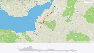
Day 15 - Truro to Land's End via Lizard Point

Image
Distance: 64.9 miles Elevation: 3983 ft Average speed: 10.7 mph https://www.strava.com/activities/2466195320 Ride report: There is less debate about the southern "end" of an end-to-end journey than there is about the north, as Land's End is definitely the pointy bit. However, the most southerly part of mainland Britain is actually at Lizard Point, to the west, so of course, I was determined to fit that in too. What this led to was quite a tough final day! After yesterday's weather, we were pleased to see that it was dry when we woke up. As someone pointed this out at breakfast, we groaned - five minutes later it was raining! It was only a few drops though, and it soon brightened again. Having had our first experience of the Cornish hills yesterday, and knowing that even though it would be our last day of riding, it wasn't an easy one, we set off with some trepidation. This wasn't helped by some early arguments with the Garmin in Truro, ending up

Day 14 - Okehampton to Truro

Image
Distance: 72.8 miles Elevation: 3630 ft Average speed: 11.7 mph https://www.strava.com/activities/2463589298 Our penultimate day on the bikes! Not too many pictures today, as perhaps predictably, it was raining steadily – but with the temperatures now at “Devon” level instead of “Scotland”, we set off in light jackets, accepting that we were just going to get wet. After not riding as far up the hill as we expected last night, we finished the job first thing this morning by making our way up to the Granite Trail. For once, the trail was actually tarmac-ed, so both bikes and riders were happier than on yesterday’s trails! In fact, it felt rather familiar after years of riding on the Bristol-Bath cycle path, particularly as we rode alongside the train tracks and past stations. We crossed the Melton viaduct – I’d have taken a picture as the views are supposed to be impressive, however we couldn’t see anything for cloud! 4 miles later, we were onto fast B roads, so with head

Day 13 - Bridgwater to Okehampton

Image
Distance: 72.5 miles Elevation: 3673 ft Average speed: 11.7 mph https://www.strava.com/activities/2460904769 Ride report to follow - the west country hills took it out of me and so I got a bit behind on the blog!

Day 12 - Bristol to Bridgwater

Image
Distance: 42.44 mi Elevation: 1278 ft Average speed: 11.6mph https://www.strava.com/activities/2457618198 Today was another "rest" day - a shorter trip and one with much less uphill overall, for which our tired legs were grateful after yesterday's exploits! It's also a part of the world we're really familiar with, as I was born in Bridgwater (well, technically Taunton, but we lived in Bridgwater), and grew up in Bristol, while Dad is from around Bridgwater originally. Leaving Cribbs Causeway, we headed through Henbury and Westbury (including up a decent hill far earlier than our legs were ready for it!). There was no let up as we then headed across the Clifton Downs towards yet another bridge. Strangely, this one was open - looks like they didn't get the memo from the Forth, Mersey and Severn bridges! Stopped for the now obligatory bridge selfie - promised Dad there wouldn't be (m)any left. Clifton Suspension bridge Climbing to the top of

Day 11 - Orleton to Bristol

Image
Distance: 69.6 miles Elevation: 4108ft Average speed: 10.7 mph https://www.strava.com/activities/2456208981 Ride report: Disclaimer: Picture above is taken from Dad's ride - I was a muppet and accidentally turned off my Garmin's recording in Monmouth, so had to restart it. We set off from Orleton with decent weather, but it wasn't long before we stopped to put the jackets on as the rain came on. We played a bit of a game of tag with some local club cyclists who'd lost the rest of their group - wonder if they ever found them? The rain stopped, and we took the jackets off. Next time it came on again, we didn't bother with them, which was probably a mistake as when we arrived in Hereford, it absolutely bucketed down, and we couldn't hide as we were stuck in traffic! We met Mum near the south of the town where she'd done her usual excellent job of locating the nearest bike racks for us! They were outside De Koffie Pot, which Mum recommended as

Day 10 - Chester to Orleton

Image
Distance: 72.7 miles Elevation: 2956 ft Average speed: 11.4 mph https://www.strava.com/activities/2452762388 Ride report: Well, if yesterday's route was ridiculous, today's was nearer sublime. We spent most of the day on minor country roads, winding our way down through the Shropshire hills (mostly avoiding them, but more on that later!) After yesterday's exploits, we were all rather tired, so we set off gently from Chester, enjoying the fact that it wasn't chucking it down with rain for once! We did get some spots of rain blowing in the wind (which unfortunately had turned overnight into a headwind), but with the route taking us down some gentle country lanes, it couldn't have been more different to yesterday. Much better road to ride on! After about 18 miles, we arrived at the Hanmer Arms and met up with Mum. We'd made it to Wales, our third country of the trip! Unfortunately, they'd stopped serving breakfast, but we got a big cafetiere

Day 9 - Forton to Chester

Image
Distance: 73.2 miles Elevation: 1898 ft Average speed: 11.4 miles https://www.strava.com/activities/2450045561 Ride report: Oh dear. Up until now, the routes I've been tinkering with for the past year have actually turned out to be pretty good - one or two miscues but mostly we've been on sensible roads and have made it from place to place without incident. That all went a little wrong today! It was always going to be a frustrating urban day, but with little climbing, we hoped it wouldn't be too challenging. Started off in the rain (again!) from the canalside cottage and did pretty well getting to Preston straight down the A6. Felt a lot like the commute at home, much less fun than some of the riding we've done on the trip so far, but at least we were making progress towards the south. Preston itself was slightly annoying due to various roadworks closing roads - where possible we pushed the bikes round them but some required some re-navigation. Once we